
Make a donation
Gear up for your next adventure:
As an Amazon Associate, this site earns from qualifying purchases at no extra cost to you.
Stratton topographic map
Click on the map to display elevation.
Make a donation
Gear up for your next adventure:
As an Amazon Associate, this site earns from qualifying purchases at no extra cost to you.
About this map
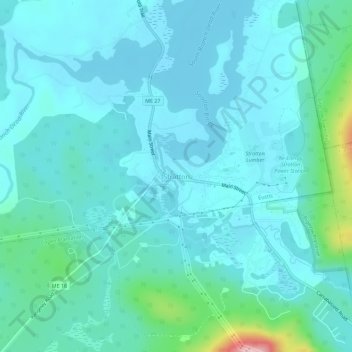
Name: Stratton topographic map, elevation, terrain.
Average elevation: 373 m
Minimum elevation: 344 m
Maximum elevation: 550 m
Make a donation
Gear up for your next adventure:
As an Amazon Associate, this site earns from qualifying purchases at no extra cost to you.
Other topographic maps
Click on a map to view its topography, its elevation and its terrain.
Make a donation
Gear up for your next adventure:
As an Amazon Associate, this site earns from qualifying purchases at no extra cost to you.
Make a donation
Gear up for your next adventure:
As an Amazon Associate, this site earns from qualifying purchases at no extra cost to you.
Avon
United States > Maine > Franklin County
According to the United States Census Bureau, the town has a total area of 41.65 square miles (107.87 km2), of which 41.39 square miles (107.20 km2) is land and 0.26 square miles (0.67 km2) is water. Avon is drained by the Sandy River, a tributary of the Kennebec River. Mount Blue, elevation 3,192 feet (973…
Average elevation: 293 m
Make a donation
Gear up for your next adventure:
As an Amazon Associate, this site earns from qualifying purchases at no extra cost to you.
Madrid Township
United States > Maine > Franklin County
Although Madrid's northern topography is mountainous, other parts suited cultivation. In 1837, when the population was 351, farms harvested 3,387 bushels of wheat.
Average elevation: 522 m
Make a donation
Gear up for your next adventure:
As an Amazon Associate, this site earns from qualifying purchases at no extra cost to you.
Make a donation
Gear up for your next adventure:
As an Amazon Associate, this site earns from qualifying purchases at no extra cost to you.
Rangeley
United States > Maine > Franklin County
This climatic region has large seasonal temperature differences, with warm (and often humid) summers and cold (sometimes severely cold) winters. According to the Köppen Climate Classification system, Rangeley has a humid continental climate, abbreviated "Dfb" on climate maps. Similar to the rest of New…
Average elevation: 548 m
Make a donation
Gear up for your next adventure:
As an Amazon Associate, this site earns from qualifying purchases at no extra cost to you.