
Make a donation
Gear up for your next adventure:
As an Amazon Associate, this site earns from qualifying purchases at no extra cost to you.
Evaton topographic map
Click on the map to display elevation.
Make a donation
Gear up for your next adventure:
As an Amazon Associate, this site earns from qualifying purchases at no extra cost to you.
About this map
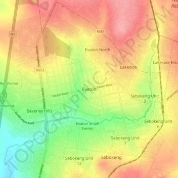
Name: Evaton topographic map, elevation, terrain.
Average elevation: 1,522 m
Minimum elevation: 1,468 m
Maximum elevation: 1,566 m
Make a donation
Gear up for your next adventure:
As an Amazon Associate, this site earns from qualifying purchases at no extra cost to you.
Other topographic maps
Click on a map to view its topography, its elevation and its terrain.
Boipatong
South Africa > Gauteng > Sedibeng District Municipality > Emfuleni Local Municipality
Average elevation: 1,478 m
Sharpeville
South Africa > Gauteng > Sedibeng District Municipality > Emfuleni Local Municipality
Average elevation: 1,459 m
Sharpeville
South Africa > Gauteng > Sedibeng District Municipality > Emfuleni Local Municipality
Average elevation: 1,459 m
Sharpeville
South Africa > Gauteng > Sedibeng District Municipality > Emfuleni Local Municipality
Average elevation: 1,459 m
Make a donation
Gear up for your next adventure:
As an Amazon Associate, this site earns from qualifying purchases at no extra cost to you.
Boipatong
South Africa > Gauteng > Sedibeng District Municipality > Emfuleni Local Municipality
Average elevation: 1,478 m
CW2
South Africa > Gauteng > Sedibeng District Municipality > Emfuleni Local Municipality
Average elevation: 1,501 m
SE10
South Africa > Gauteng > Sedibeng District Municipality > Emfuleni Local Municipality
Average elevation: 1,462 m
SE8
South Africa > Gauteng > Sedibeng District Municipality > Emfuleni Local Municipality
Average elevation: 1,456 m
Make a donation
Gear up for your next adventure:
As an Amazon Associate, this site earns from qualifying purchases at no extra cost to you.
SE1
South Africa > Gauteng > Sedibeng District Municipality > Emfuleni Local Municipality
Average elevation: 1,480 m