Geolocate

Wilsden topographic map

Click on the map to display elevation.

About this map

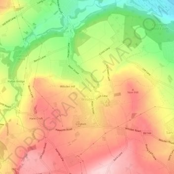
Name: Wilsden topographic map, elevation, terrain.

Location: Wilsden, Bradford, West Yorkshire, England, United Kingdom (53.80791 -1.88988 53.83996 -1.83689)

Average elevation: 207 m

Minimum elevation: 74 m

Maximum elevation: 308 m

Other topographic maps

Click on a map to view its topography, its elevation and its terrain.

Hare Croft

United Kingdom > England > Bradford > Wilsden

Average elevation: 234 m

Gear up for your next adventure:

🦶Orthotic Hiking Insoles - Extra arch support for long-distance topographic treks
🎒40L Day Hiking Backpacks - Comfortable packs with hydration support for long days exploring topographic peaks
🐍Snake Gaiters - Protection against snake bites
🎧Bluetooth Outdoor Earbuds - Listen to navigation cues or podcasts during long solo treks
🧥Softshell Jackets - Flexible outdoor jackets

As an Amazon Associate, this site earns from qualifying purchases at no extra cost to you.