
Make a donation
Gear up for your next adventure:
As an Amazon Associate, this site earns from qualifying purchases at no extra cost to you.
Aberystwyth topographic map
Click on the map to display elevation.
Make a donation
Gear up for your next adventure:
As an Amazon Associate, this site earns from qualifying purchases at no extra cost to you.
Aberystwyth
Aberystwyth experiences an oceanic climate (Köppen climate classification Cfb) similar to almost all of the United Kingdom. This is particularly pronounced due to its west coast location facing the Irish Sea. Air undergoes little land moderation and so temperatures closely reflect the sea temperature when winds are coming from the predominant onshore (westerly) direction. The nearest Met Office weather station is Gogerddan, 3 miles to the northeast, and at a similar elevation.
Make a donation
Gear up for your next adventure:
As an Amazon Associate, this site earns from qualifying purchases at no extra cost to you.
About this map
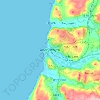
Name: Aberystwyth topographic map, elevation, terrain.
Location: Aberystwyth, Ceredigion, Wales, SY23 1LH, United Kingdom (52.37431 -4.12168 52.45431 -4.04168)
Average elevation: 39 m
Minimum elevation: -1 m
Maximum elevation: 195 m
Make a donation
Gear up for your next adventure:
As an Amazon Associate, this site earns from qualifying purchases at no extra cost to you.
Other topographic maps
Click on a map to view its topography, its elevation and its terrain.
Make a donation
Gear up for your next adventure:
As an Amazon Associate, this site earns from qualifying purchases at no extra cost to you.
Make a donation
Gear up for your next adventure:
As an Amazon Associate, this site earns from qualifying purchases at no extra cost to you.
Make a donation
Gear up for your next adventure:
As an Amazon Associate, this site earns from qualifying purchases at no extra cost to you.
Newcastle Emlyn Castle
United Kingdom > Wales > Ceredigion > Adpar > Bryndioddef
Average elevation: 78 m
Make a donation
Gear up for your next adventure:
As an Amazon Associate, this site earns from qualifying purchases at no extra cost to you.