
Make a donation
Gear up for your next adventure:
As an Amazon Associate, this site earns from qualifying purchases at no extra cost to you.
Lake Roberts topographic map
Click on the map to display elevation.
Make a donation
Gear up for your next adventure:
As an Amazon Associate, this site earns from qualifying purchases at no extra cost to you.
About this map
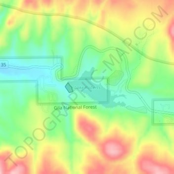
Name: Lake Roberts topographic map, elevation, terrain.
Location: Lake Roberts, Grant County, New Mexico, United States (33.02773 -108.16519 33.03404 -108.15425)
Average elevation: 1,892 m
Minimum elevation: 1,818 m
Maximum elevation: 1,983 m
Make a donation
Gear up for your next adventure:
As an Amazon Associate, this site earns from qualifying purchases at no extra cost to you.
Other topographic maps
Click on a map to view its topography, its elevation and its terrain.
Make a donation
Gear up for your next adventure:
As an Amazon Associate, this site earns from qualifying purchases at no extra cost to you.
Basin and Range Country Historical Marker
United States > New Mexico > Grant County
Average elevation: 1,393 m