
Make a donation
Gear up for your next adventure:
As an Amazon Associate, this site earns from qualifying purchases at no extra cost to you.
Broomfield topographic map
Click on the map to display elevation.
Make a donation
Gear up for your next adventure:
As an Amazon Associate, this site earns from qualifying purchases at no extra cost to you.
Broomfield
The elevation in Broomfield ranges from 5,096 to 5,856 feet. At the 2020 United States Census, Broomfield had a total area of 21,471 acres (86.890 km2) including 371 acres (1.503 km2) of water. It is the smallest county by area in Colorado and the 5th smallest in the United States. Broomfield is the second most densely populated county in Colorado behind Denver.
Make a donation
Gear up for your next adventure:
As an Amazon Associate, this site earns from qualifying purchases at no extra cost to you.
About this map
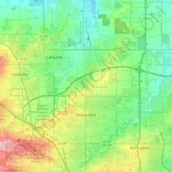
Name: Broomfield topographic map, elevation, terrain.
Location: Broomfield, Colorado, United States (39.88920 -105.16726 40.04423 -104.96093)
Average elevation: 1,609 m
Minimum elevation: 1,532 m
Maximum elevation: 1,777 m
Make a donation
Gear up for your next adventure:
As an Amazon Associate, this site earns from qualifying purchases at no extra cost to you.