
Vännäs kommun topographic map
Interactive map
Click on the map to display elevation.
About this map
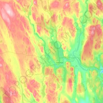
Name: Vännäs kommun topographic map, elevation, terrain.
Location: Vännäs kommun, Västerbotten County, Sweden (63.78846 19.41814 64.08554 19.98266)
Average elevation: 168 m
Minimum elevation: 61 m
Maximum elevation: 326 m
Other topographic maps
Click on a map to view its topography, its elevation and its terrain.
Lycksele kommun
Lycksele kommun, Västerbotten County, Sweden
Average elevation: 356 m
Vibo
Sweden > Västerbotten County > Nordmaling District
Vibo, Nordmaling District, Nordmalings kommun, Västerbotten County, Sweden
Average elevation: 130 m
Skellefteå kommun
Skellefteå kommun, Västerbotten County, Sweden
Average elevation: 104 m