
Make a donation
Gear up for your next adventure:
As an Amazon Associate, this site earns from qualifying purchases at no extra cost to you.
Driedorf topographic map
Click on the map to display elevation.
Make a donation
Gear up for your next adventure:
As an Amazon Associate, this site earns from qualifying purchases at no extra cost to you.
Driedorf
Driedorf liegt auf einer Hochfläche im hohen Westerwald in einer Höhe von 416 bis 643 Meter. Mit dem Höllberg liegt der höchste hessische Berg des Westerwalds in dem Gemeindegebiet.
Make a donation
Gear up for your next adventure:
As an Amazon Associate, this site earns from qualifying purchases at no extra cost to you.
About this map
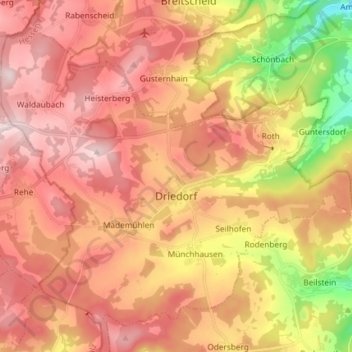
Name: Driedorf topographic map, elevation, terrain.
Location: Driedorf, Lahn-Dill-Kreis, Hessen, 35759, Deutschland (50.59872 8.10988 50.67811 8.25683)
Average elevation: 503 m
Minimum elevation: 270 m
Maximum elevation: 654 m
Make a donation
Gear up for your next adventure:
As an Amazon Associate, this site earns from qualifying purchases at no extra cost to you.