
Make a donation
Gear up for your next adventure:
As an Amazon Associate, this site earns from qualifying purchases at no extra cost to you.
Kundiawa topographic map
Click on the map to display elevation.
Make a donation
Gear up for your next adventure:
As an Amazon Associate, this site earns from qualifying purchases at no extra cost to you.
Kundiawa
Kundiawa has a relatively cool tropical rainforest climate (Köppen Af), bordering on a subtropical highland climate (Cfb) due to altitude. It features mild mornings, very warm but not hot afternoons, and heavy rainfall year round.
Make a donation
Gear up for your next adventure:
As an Amazon Associate, this site earns from qualifying purchases at no extra cost to you.
About this map
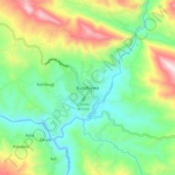
Name: Kundiawa topographic map, elevation, terrain.
Average elevation: 2,077 m
Minimum elevation: 1,270 m
Maximum elevation: 3,628 m
Make a donation
Gear up for your next adventure:
As an Amazon Associate, this site earns from qualifying purchases at no extra cost to you.