
Make a donation
Gear up for your next adventure:
As an Amazon Associate, this site earns from qualifying purchases at no extra cost to you.
Eindhoven topographic map
Click on the map to display elevation.
Make a donation
Gear up for your next adventure:
As an Amazon Associate, this site earns from qualifying purchases at no extra cost to you.
Eindhoven
The villages and city that make up modern Eindhoven were originally built on sandy elevations between the Dommel, Gender and Tongelreep rivers. Beginning in the 19th century, the basins of the rivers themselves have also been used as housing land, resulting in occasional flooding in the city centre. Partly to reduce flooding, the bed of the Gender stream, which flowed directly through the city centre, was dammed off and filled up after the War, and the course of the Dommel was regulated. New ecological and socio-historical insights have led to parts of the Dommel's course being restored to their original states, and plans to have the Gender flow through the centre once again.
Make a donation
Gear up for your next adventure:
As an Amazon Associate, this site earns from qualifying purchases at no extra cost to you.
About this map
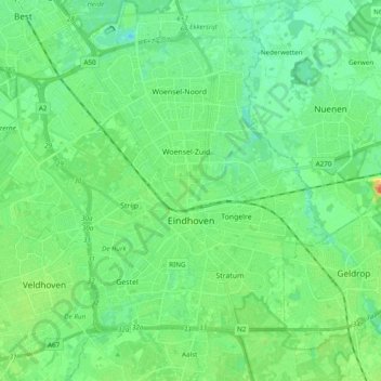
Name: Eindhoven topographic map, elevation, terrain.
Location: Eindhoven, North Brabant, Netherlands (51.40005 5.35672 51.49708 5.54885)
Average elevation: 20 m
Minimum elevation: 6 m
Maximum elevation: 54 m
Make a donation
Gear up for your next adventure:
As an Amazon Associate, this site earns from qualifying purchases at no extra cost to you.
Other topographic maps
Click on a map to view its topography, its elevation and its terrain.
Eindhoven
Netherlands > North Brabant > Eindhoven
The villages and city that make up modern Eindhoven were originally built on sandy elevations between the Dommel, Gender and Tongelreep rivers. Beginning in the 19th century, the basins of the rivers themselves have also been used as housing land, resulting in occasional flooding in the city centre. Partly to…
Average elevation: 21 m