
Crathie topographic map
Interactive map
Click on the map to display elevation.
About this map
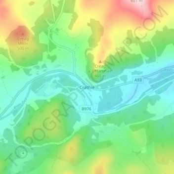
Name: Crathie topographic map, elevation, terrain.
Location: Crathie, Aberdeenshire, Scotland, AB35 5UL, United Kingdom (57.01950 -3.23496 57.05950 -3.19496)
Average elevation: 359 m
Minimum elevation: 255 m
Maximum elevation: 588 m
Other topographic maps
Click on a map to view its topography, its elevation and its terrain.
Kirkton of Tough
United Kingdom > Scotland > Aberdeenshire
Kirkton of Tough, Aberdeenshire, Scotland, AB33 8ER, United Kingdom
Average elevation: 210 m
East Mains
United Kingdom > Scotland > Aberdeenshire > Banchory
East Mains, Banchory, Aberdeenshire, Scotland, AB31 4BG, United Kingdom
Average elevation: 99 m
Braemar
United Kingdom > Scotland > Aberdeenshire
Braemar, Aberdeenshire, Scotland, AB35 5YN, United Kingdom
Average elevation: 445 m
Findon
United Kingdom > Scotland > Aberdeenshire > Findon
Findon, Aberdeenshire, Scotland, AB12 3RP, United Kingdom
Average elevation: 45 m
Peterhead
United Kingdom > Scotland > Aberdeenshire
Peterhead, Aberdeenshire, Scotland, AB42 1ZP, United Kingdom
Average elevation: 17 m
Huntly
United Kingdom > Scotland > Aberdeenshire
Huntly, Aberdeenshire, Scotland, AB54 8AE, United Kingdom
Average elevation: 171 m
Redstone Hill
United Kingdom > Scotland > Aberdeenshire
Redstone Hill, Aberdeenshire, Scotland, AB30 1HB, United Kingdom
Average elevation: 306 m