
Rotspitze topographic map
Interactive map
Click on the map to display elevation.
About this map
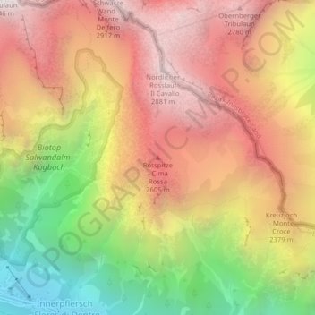
Name: Rotspitze topographic map, elevation, terrain.
Location: Rotspitze, Brenner, Wipptal, Bozen, Trentino-Südtirol, Italien (46.97625 11.36530 46.97635 11.36540)
Average elevation: 2,166 m
Minimum elevation: 1,215 m
Maximum elevation: 2,914 m
Other topographic maps
Click on a map to view its topography, its elevation and its terrain.
Pflersch
Italien > Trentino-Südtirol > Brenner
Pflersch, Brenner, Wipptal, Bozen, Trentino-Südtirol, 39041, Italien
Average elevation: 1,905 m