
Wöhrsee topographic map
Interactive map
Click on the map to display elevation.
About this map
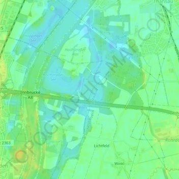
Name: Wöhrsee topographic map, elevation, terrain.
Average elevation: 450 m
Minimum elevation: 441 m
Maximum elevation: 462 m
Other topographic maps
Click on a map to view its topography, its elevation and its terrain.
Aich
Deutschland > Bayern > Landkreis Rosenheim > Raubling > Großholzhausen
Aich, Großholzhausen, Raubling, Landkreis Rosenheim, Bayern, 83064, Deutschland
Average elevation: 470 m
Obermühl
Deutschland > Bayern > Landkreis Rosenheim > Raubling > Reischenhart > Obermühl
Obermühl, Reischenhart, Raubling, Landkreis Rosenheim, Bayern, 83064, Deutschland
Average elevation: 463 m