
Ilha Ellesmere topographic map
Interactive map
Click on the map to display elevation.
About this map
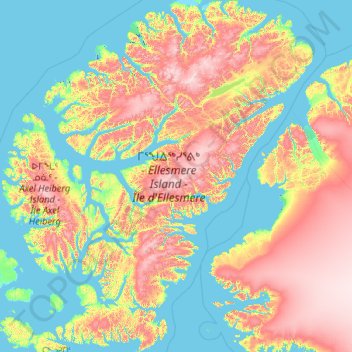
Name: Ilha Ellesmere topographic map, elevation, terrain.
Location: Ilha Ellesmere, Nunavut, X0A 0J0, Canadá (76.13171 -91.90137 83.11148 -61.09132)
Average elevation: 495 m
Minimum elevation: -5 m
Maximum elevation: 2,446 m
Other topographic maps
Click on a map to view its topography, its elevation and its terrain.
ᕿᑎᕐᒥᐅᑦ Kitikmeot Region
ᕿᑎᕐᒥᐅᑦ Kitikmeot Region, Nunavut, Canadá
Average elevation: 142 m
ᕿᑭᖅᑖᓗᒃ Qikiqtaaluk Region
ᕿᑭᖅᑖᓗᒃ Qikiqtaaluk Region, Nunavut, Canadá
Average elevation: 373 m