
Make a donation
Gear up for your next adventure:
As an Amazon Associate, this site earns from qualifying purchases at no extra cost to you.
Tagum topographic map
Click on the map to display elevation.
Make a donation
Gear up for your next adventure:
As an Amazon Associate, this site earns from qualifying purchases at no extra cost to you.
Tagum
One of the significant accomplishments of the officialdom of Tagum during the 1990s was its elevation from a second to the first-class municipality. This opened a gateway to increase its financial resources through the Internal Revenue Allocation (IRA) from the national government and local revenues. This was under the leadership of Hon Victorio R. Suaybaguio, Jr. who sat as mayor Tagum for three consecutive terms (1988–1998). As a matter of fact, during the 1995 election, all incumbent elected officials of Tagum, from Mayor down to the municipal councilors, were unopposed, making a significant event in the political history of Tagum.
Make a donation
Gear up for your next adventure:
As an Amazon Associate, this site earns from qualifying purchases at no extra cost to you.
About this map
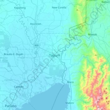
Name: Tagum topographic map, elevation, terrain.
Location: Tagum, Davao del Norte, Davao Region, 8100, Philippines (7.28702 125.65118 7.60702 125.97118)
Average elevation: 103 m
Minimum elevation: 0 m
Maximum elevation: 1,143 m
Make a donation
Gear up for your next adventure:
As an Amazon Associate, this site earns from qualifying purchases at no extra cost to you.
Other topographic maps
Click on a map to view its topography, its elevation and its terrain.
Faith Tabernacle Church Sto. Tomas
Philippines > Davao del Norte > Santo Tomas
Average elevation: 36 m
Make a donation
Gear up for your next adventure:
As an Amazon Associate, this site earns from qualifying purchases at no extra cost to you.