
Lonsdale topographic map
Interactive map
Click on the map to display elevation.
About this map
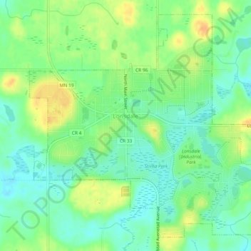
Name: Lonsdale topographic map, elevation, terrain.
Location: Lonsdale, Rice County, Minnesota, 55046, United States (44.46424 -93.44636 44.49361 -93.39999)
Average elevation: 336 m
Minimum elevation: 322 m
Maximum elevation: 356 m
Other topographic maps
Click on a map to view its topography, its elevation and its terrain.
Dundas
United States > Minnesota > Rice County
Dundas, Rice County, Minnesota, United States
Average elevation: 297 m
Northfield
United States > Minnesota > Rice County
Northfield, Rice County, Minnesota, 55057, United States
Average elevation: 300 m