Geolocate

Psathi topographic map

Click on the map to display elevation.

About this map

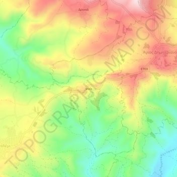
Name: Psathi topographic map, elevation, terrain.

Location: Psathi, Paphos District, 8545, Cyprus (34.87847 32.51087 34.91847 32.55087)

Average elevation: 441 m

Minimum elevation: 258 m

Maximum elevation: 634 m

Gear up for your next adventure:

🔦LED Torches - LED torches for outdoor use
🧼Biodegradable Soap - Eco-friendly outdoor soap
📖Australian Bush Survival Books - Local knowledge on finding water and surviving the outback
🥾Heavy Duty Hiking Boots - Ankle-supporting boots for carrying heavy packs on steep contours
🧢Wide Brim Sun Hats - Maximum coverage for the face and neck while out in the open

As an Amazon Associate, this site earns from qualifying purchases at no extra cost to you.