
Make a donation
Gear up for your next adventure:
As an Amazon Associate, this site earns from qualifying purchases at no extra cost to you.
Kashan topographic map
Click on the map to display elevation.
Make a donation
Gear up for your next adventure:
As an Amazon Associate, this site earns from qualifying purchases at no extra cost to you.
Kashan
Kashan has a hot desert climate, with (BWh) designation in Köppen climate classification and (BW) in Trewartha climate classification, with cold winters (although warmer than other Iranian cities) and very hot and dry summers. Kashan is significantly warmer than other cities in the Iranian Plateau due to its lower elevation.
Make a donation
Gear up for your next adventure:
As an Amazon Associate, this site earns from qualifying purchases at no extra cost to you.
About this map
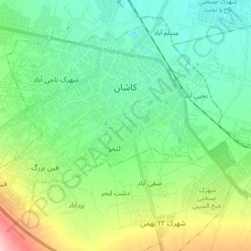
Name: Kashan topographic map, elevation, terrain.
Average elevation: 964 m
Minimum elevation: 910 m
Maximum elevation: 1,112 m
Make a donation
Gear up for your next adventure:
As an Amazon Associate, this site earns from qualifying purchases at no extra cost to you.