
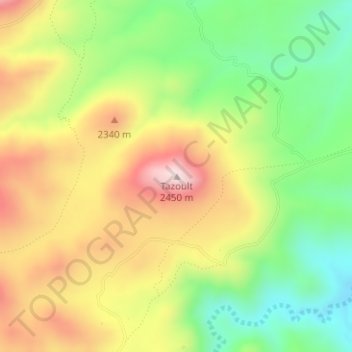
Tazoult topographic map
Interactive map
Click on the map to display elevation.
About this map
Name: Tazoult topographic map, elevation, terrain.
Average elevation: 2,232 m
Minimum elevation: 2,040 m
Maximum elevation: 2,451 m
Other topographic maps
Click on a map to view its topography, its elevation and its terrain.
Ait Qalla
Maroc > cercle d'Amerzgane > Khouzama
Ait Qalla, Khouzama, caïdat de Anzal, cercle d'Amerzgane, Province de Ouarzazate, Drâa-Tafilalet, Maroc
Average elevation: 2,136 m
Khouzama
Maroc > cercle d'Amerzgane > Khouzama > Tachakchte
Khouzama, Tachakchte, Khouzama, caïdat de Anzal, cercle d'Amerzgane, Province de Ouarzazate, Drâa-Tafilalet, Maroc
Average elevation: 1,985 m