Geolocate

Bulac topographic map

Click on the map to display elevation.

About this map

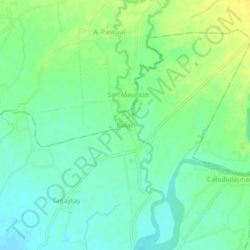
Name: Bulac topographic map, elevation, terrain.

Location: Bulac, Talavera, Nueva Ecija, Central Luzon, Philippines (15.66298 120.95077 15.70298 120.99077)

Average elevation: 68 m

Minimum elevation: 58 m

Maximum elevation: 80 m

Other topographic maps

Click on a map to view its topography, its elevation and its terrain.

Talavera River

Philippines > Nueva Ecija > Talavera

Average elevation: 47 m

Gear up for your next adventure:

🧺Fast-Dry Microfiber Towels - Large towels that pack down to the size of an orange
👕UPF 50+ Sun Shirts - Essential protection against the harsh Australian sun during field work
👄SPF Lip Balm - Prevent sun and wind-burnt lips on mountain ridges
🔌Fast Charging Adapters - Quickly top up all your gear before heading back into the field
☀️Portable Solar Chargers - High-efficiency panels to hang on your backpack while walking

As an Amazon Associate, this site earns from qualifying purchases at no extra cost to you.