
Gunpowder topographic map
Interactive map
Click on the map to display elevation.
About this map
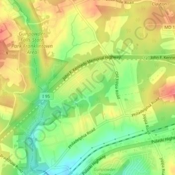
Name: Gunpowder topographic map, elevation, terrain.
Average elevation: 38 m
Minimum elevation: 3 m
Maximum elevation: 69 m
Other topographic maps
Click on a map to view its topography, its elevation and its terrain.
Deep Creek Lake
United States of America > Maryland > Green Glade
Deep Creek Lake, Garrett County, Maryland, 21541, United States of America
Average elevation: 793 m
Annapolis
United States of America > Maryland > Annapolis
Annapolis, Anne Arundel County, Maryland, United States of America
Average elevation: 8 m
Reid
United States of America > Maryland > Reid
Reid, Washington County, Maryland, 17263, United States of America
Average elevation: 188 m
Guys
United States of America > Maryland > Grasonville > Guys
Guys, Grasonville, Queen Anne's County, Maryland, 21658, United States of America
Average elevation: 5 m
Country Side
United States of America > Maryland > Country Side
Country Side, Frederick County, Maryland, 21704, United States of America
Average elevation: 88 m
Lynchs Corner
United States of America > Maryland > Lynchs Corner
Lynchs Corner, Pleasant Hills, Harford County, Maryland, 21018, United States of America
Average elevation: 115 m
Peppermint Park
United States of America > Maryland > Peppermint Park
Peppermint Park, Carroll County, Maryland, 21157, United States of America
Average elevation: 230 m
Nottingham
United States of America > Maryland > Nottingham
Nottingham, Linthicum, Anne Arundel County, Maryland, 21062, United States of America
Average elevation: 37 m
Moore Creek
United States of America > Maryland
Moore Creek, Wicomico County, Maryland, United States of America
Average elevation: 6 m
College Park
United States of America > Maryland > College Park
College Park, Prince George's County, Maryland, United States of America
Average elevation: 38 m
South River
United States of America > Maryland > Withernsea
South River, Rolling Road, Annapolis Landing, Withernsea, Anne Arundel County, Maryland, 21037, United States of America
Average elevation: 10 m