
Gisborne Point topographic map
Interactive map
Click on the map to display elevation.
About this map
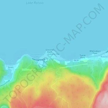
Name: Gisborne Point topographic map, elevation, terrain.
Average elevation: 350 m
Minimum elevation: 279 m
Maximum elevation: 591 m
Other topographic maps
Click on a map to view its topography, its elevation and its terrain.
Waiotapu Village
New Zealand > Bay of Plenty > Rotorua Lakes District
Waiotapu Village, Rotorua Lakes District, Bay of Plenty, New Zealand
Average elevation: 438 m
Rotorua
New Zealand > Bay of Plenty > Rotorua Lakes District
Rotorua, Rotorua Lakes District, Bay of Plenty, 3010, New Zealand
Average elevation: 435 m
Okere Falls
New Zealand > Bay of Plenty > Rotorua Lakes District
Okere Falls, Rotorua Lakes District, Bay of Plenty, New Zealand
Average elevation: 318 m
Waimangu
New Zealand > Bay of Plenty > Rotorua Lakes District
Waimangu, Rotorua Lakes District, Bay of Plenty, New Zealand
Average elevation: 448 m