Geolocate

West Perth topographic map

Click on the map to display elevation.

About this map

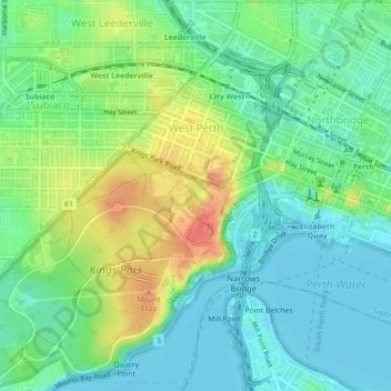
Name: West Perth topographic map, elevation, terrain.

Location: West Perth, City of Perth, Western Australia, 6005, Australia (-31.97377 115.81787 -31.93644 115.85835)

Average elevation: 26 m

Minimum elevation: 0 m

Maximum elevation: 81 m

City of Perth trails, hiking, mountain biking, running and outdoor activities

Other topographic maps

Click on a map to view its topography, its elevation and its terrain.

Perth

Australia > Western Australia > City of Perth

Perth, the capital of Western Australia, is situated on the Swan Coastal Plain, a flat expanse of sandy soil nestled between the Indian Ocean to the west and the Darling Scarp to the east. The Darling Scarp, also known as the Darling Range, is a low escarpment that extends north–south, marking a distinct…

Average elevation: 26 m

Kings Park

Australia > Western Australia > City of Perth > Perth

Average elevation: 31 m

Perth

Australia > Western Australia > City of Perth

Perth, the capital of Western Australia, is situated on the Swan Coastal Plain, a flat expanse of sandy soil nestled between the Indian Ocean to the west and the Darling Scarp to the east. The Darling Scarp, also known as the Darling Range, is a low escarpment that extends north–south, marking a distinct…

Average elevation: 26 m

Perth

Australia > Western Australia > City of Perth

Average elevation: 26 m

Perth

Australia > Western Australia > City of Perth

Average elevation: 26 m

Perth

Australia > Western Australia > City of Perth

Perth, the capital of Western Australia, is situated on the Swan Coastal Plain, a flat expanse of sandy soil nestled between the Indian Ocean to the west and the Darling Scarp to the east. The Darling Scarp, also known as the Darling Range, is a low escarpment that extends north–south, marking a distinct…

Average elevation: 26 m

Perth

Australia > Western Australia > City of Perth

Perth, the capital of Western Australia, is situated on the Swan Coastal Plain, a flat expanse of sandy soil nestled between the Indian Ocean to the west and the Darling Scarp to the east. The Darling Scarp, also known as the Darling Range, is a low escarpment that extends north–south, marking a distinct…

Average elevation: 26 m

Gear up for your next adventure:

🏃Compression Recovery Socks - Reduce leg fatigue after heavy days of elevation gain
🧥Softshell Jackets - Flexible outdoor jackets
🧭Military Style Lensatic Compass - Durable sighting compasses for advanced land navigation and surveying
🧰Survival Kits - Essential survival gear
🔪Outdoor Multi-tools - Versatile tools for gear repair and survival tasks in the wilderness

As an Amazon Associate, this site earns from qualifying purchases at no extra cost to you.