
Olpe topographic map
Interactive map
Click on the map to display elevation.
About this map
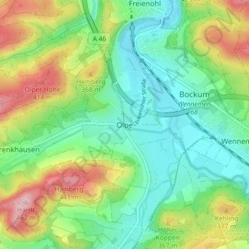
Name: Olpe topographic map, elevation, terrain.
Average elevation: 302 m
Minimum elevation: 225 m
Maximum elevation: 449 m
Other topographic maps
Click on a map to view its topography, its elevation and its terrain.
Freienohl
Deutschland > Nordrhein-Westfalen > Hochsauerlandkreis > Meschede
Freienohl, Meschede, Hochsauerlandkreis, Nordrhein-Westfalen, Deutschland
Average elevation: 298 m