
Huíla Province topographic map
Interactive map
Click on the map to display elevation.
About this map
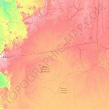
Name: Huíla Province topographic map, elevation, terrain.
Location: Huíla Province, Angola (-16.34705 13.20928 -13.33222 16.75552)
Average elevation: 1,318 m
Minimum elevation: 435 m
Maximum elevation: 2,369 m
Other topographic maps
Click on a map to view its topography, its elevation and its terrain.
Porto Amboim
Porto Amboim, Cuanza Sul Province, Angola
Average elevation: 24 m
Luanda
Angola > Luanda Province > Municipality of Luanda
Luanda, Municipality of Luanda, Luanda Province, Angola
Average elevation: 44 m