Dalefield topographic map
Interactive map
Click on the map to display elevation.
About this map
![Dalefield topographic map, elevation, terrain](/pub/maps/node/72zs/7v36ls18/thumbnail.jpg)
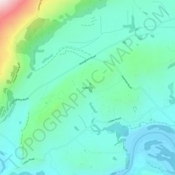
Name: Dalefield topographic map, elevation, terrain.
Location: Dalefield, Queenstown-Lakes District, Otago, New Zealand (-44.98795 168.70160 -44.94795 168.74160)
Average elevation: 475 m
Minimum elevation: 322 m
Maximum elevation: 1,067 m
Other topographic maps
Click on a map to view its topography, its elevation and its terrain.
![Lake Alta topographic map, elevation, terrain](/pub/maps/way/blt6/ctk45z4/icon.jpg)
Lake Alta
New Zealand > Otago > Queenstown-Lakes District
Lake Alta, Queenstown-Lakes District, Otago, New Zealand
Average elevation: 1,840 m
![Wānaka topographic map, elevation, terrain](/pub/maps/node/mlgt/fggd8gp/icon.jpg)
Wānaka
New Zealand > Otago > Queenstown-Lakes District
Wānaka, Queenstown-Lakes District, Otago, 9305, New Zealand
Average elevation: 381 m
![Glenorchy topographic map, elevation, terrain](/pub/maps/node/9f4s/74sspdn/icon.jpg)
Glenorchy
New Zealand > Otago > Queenstown-Lakes District
Glenorchy, Queenstown-Lakes District, Otago, 9372, New Zealand
Average elevation: 384 m
![Mount Selwyn topographic map, elevation, terrain](/pub/maps/node/sxgp/23rx4nkl/icon.jpg)
Mount Selwyn
New Zealand > Otago > Queenstown-Lakes District
Mount Selwyn, Queenstown-Lakes District, Otago, New Zealand
Average elevation: 853 m
![Blanket Bay topographic map, elevation, terrain](/pub/maps/node/3s51/jqzls8nh/icon.jpg)
Blanket Bay
New Zealand > Otago > Queenstown-Lakes District
Blanket Bay, Queenstown-Lakes District, Otago, 9372, New Zealand
Average elevation: 337 m
![Kingston topographic map, elevation, terrain](/pub/maps/node/q457/9zg8nf3/icon.jpg)
Kingston
New Zealand > Otago > Queenstown-Lakes District
Kingston, Queenstown-Lakes District, Otago, New Zealand
Average elevation: 507 m
![Matukituki River topographic map, elevation, terrain](/pub/maps/way/rbnx/sfpc7gt/icon.jpg)
Matukituki River
New Zealand > Otago > Queenstown-Lakes District
Matukituki River, Queenstown-Lakes District, Otago, New Zealand
Average elevation: 337 m
![Queenstown topographic map, elevation, terrain](/pub/maps/node/34tp/lwkkqmt/icon.jpg)
Queenstown
New Zealand > Otago > Queenstown-Lakes District
Queenstown, Queenstown-Lakes District, Otago, 9348, New Zealand
Average elevation: 592 m