
Make a donation
Gear up for your next adventure:
As an Amazon Associate, this site earns from qualifying purchases at no extra cost to you.
Lock Haven topographic map
Click on the map to display elevation.
Make a donation
Gear up for your next adventure:
As an Amazon Associate, this site earns from qualifying purchases at no extra cost to you.
About this map
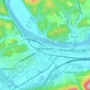
Name: Lock Haven topographic map, elevation, terrain.
Location: Lock Haven, Clinton County, Pennsylvania, United States (41.12380 -77.47479 41.15391 -77.41364)
Average elevation: 205 m
Minimum elevation: 156 m
Maximum elevation: 475 m
Make a donation
Gear up for your next adventure:
As an Amazon Associate, this site earns from qualifying purchases at no extra cost to you.
Other topographic maps
Click on a map to view its topography, its elevation and its terrain.
Farrandsville
United States > Pennsylvania > Clinton County > Colebrook Township
Average elevation: 293 m
Make a donation
Gear up for your next adventure:
As an Amazon Associate, this site earns from qualifying purchases at no extra cost to you.
Riverview
United States > Pennsylvania > Clinton County > Bald Eagle Township > Riverview
Average elevation: 295 m