
Fabara topographic map
Interactive map
Click on the map to display elevation.
About this map
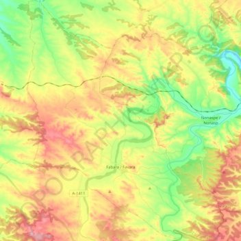
Name: Fabara topographic map, elevation, terrain.
Location: Fabara, Bajo Aragón-Caspe, Zaragoza, Aragón, 50793, España (41.12983 0.08721 41.28530 0.25615)
Average elevation: 248 m
Minimum elevation: 105 m
Maximum elevation: 422 m
Other topographic maps
Click on a map to view its topography, its elevation and its terrain.
Febrero
España > Aragón > Bajo Aragón-Caspe > Caspe
Febrero, Caspe, Bajo Aragón-Caspe, Zaragoza, Aragón, España
Average elevation: 136 m