
Tremp topographic map
Interactive map
Click on the map to display elevation.
About this map
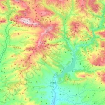
Name: Tremp topographic map, elevation, terrain.
Location: Tremp, Pallars Jussà, Lerida, Catalonië, 22583, Spanje (42.10998 0.69530 42.37588 0.97176)
Average elevation: 908 m
Minimum elevation: 380 m
Maximum elevation: 1,876 m
Other topographic maps
Click on a map to view its topography, its elevation and its terrain.
Senterada
Spanje > Catalonië > Pallars Jussà
Senterada, Pallars Jussà, Catalonië, 25514, Spanje
Average elevation: 1,143 m
Cellers
Spanje > Catalonië > Pallars Jussà
Cellers, Castell de Mur, Pallars Jussà, Lerida, Catalonië, 25631, Spanje
Average elevation: 492 m