
Ingonish topographic map
Click on the map to display elevation.
About this map
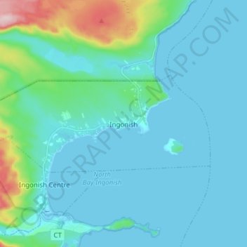
Name: Ingonish topographic map, elevation, terrain.
Average elevation: 39 m
Minimum elevation: -1 m
Maximum elevation: 289 m
Other topographic maps
Click on a map to view its topography, its elevation and its terrain.
Sandy Beach
Canada > Nova Scotia > Municipality of Victoria County > Cape Dauphin
Average elevation: 54 m
Shoal Point
Canada > Nova Scotia > Municipality of Victoria County > New Haven
Average elevation: 19 m
Pattersons Lake
Canada > Nova Scotia > Municipality of Victoria County > Boularderie East
Average elevation: 84 m