
Lhers topographic map
Interactive map
Click on the map to display elevation.
About this map
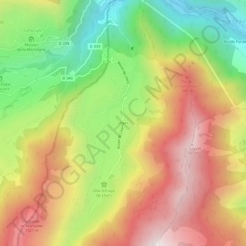
Name: Lhers topographic map, elevation, terrain.
Average elevation: 1,108 m
Minimum elevation: 499 m
Maximum elevation: 1,715 m
Other topographic maps
Click on a map to view its topography, its elevation and its terrain.
Lac du Montagnon
France > Nouvelle-Aquitaine > Pyrénées-Atlantiques > Accous
Lac du Montagnon, Accous, Oloron-Sainte-Marie, Pyrénées-Atlantiques, Nouvelle-Aquitaine, France métropolitaine, 64490, France
Average elevation: 1,771 m