
Dexter topographic map
Click on the map to display elevation.
About this map
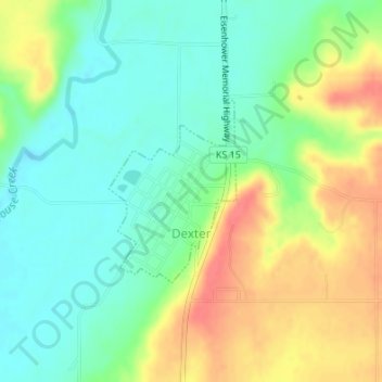
Name: Dexter topographic map, elevation, terrain.
Location: Dexter, Cowley County, Kansas, United States (37.17376 -96.72179 37.18666 -96.71046)
Average elevation: 374 m
Minimum elevation: 349 m
Maximum elevation: 410 m
Other topographic maps
Click on a map to view its topography, its elevation and its terrain.
Arkansas City
United States > Kansas > Cowley County > Arkansas City > Arkansas City
Average elevation: 339 m