Geolocate

Hawkwell topographic map

Click on the map to display elevation.

About this map

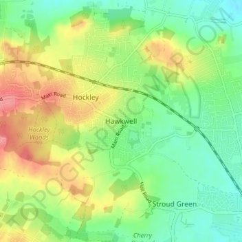
Name: Hawkwell topographic map, elevation, terrain.

Location: Hawkwell, Rochford, Essex, England, SS5 4EG, United Kingdom (51.57709 0.64641 51.61709 0.68641)

Average elevation: 32 m

Minimum elevation: 1 m

Maximum elevation: 75 m

Other topographic maps

Click on a map to view its topography, its elevation and its terrain.

Hullbridge

United Kingdom > England > Essex > Rochford > Hullbridge

Average elevation: 20 m

Rochford

United Kingdom > England > Essex > Rochford > Stroud Green

Average elevation: 26 m

Ashingdon

United Kingdom > England > Essex > Rochford

Average elevation: 14 m

Sutton

United Kingdom > England > Essex > Rochford > Sutton

Average elevation: 10 m

Foulness Island

United Kingdom > England > Essex > Rochford

Average elevation: 1 m

Potash Woods

United Kingdom > England > Essex > Rochford > Hawkwell

Average elevation: 29 m

Foulness Island

United Kingdom > England > Essex > Rochford

Average elevation: 1 m

Gear up for your next adventure:

👣Snake & Scrub Gaiters - Protection against spinifex, mud, and snakes while walking off-track
📱Shockproof Phone Cases - Extra protection for your smartphone against drops on rocky terrain
🔥Camping Stoves - Portable stoves for outdoor cooking
🎒Hiking Backpacks - Backpacks designed for hiking and trekking
🧊Insulated Stainless Steel Flasks - Keep water cold for 24 hours in the heat or coffee hot in the cold

As an Amazon Associate, this site earns from qualifying purchases at no extra cost to you.