
Make a donation
Gear up for your next adventure:
As an Amazon Associate, this site earns from qualifying purchases at no extra cost to you.
Baierbrunn topographic map
Click on the map to display elevation.
Make a donation
Gear up for your next adventure:
As an Amazon Associate, this site earns from qualifying purchases at no extra cost to you.
Baierbrunn
Auf der Flur Konradshöhe am südöstlichen Ortsrand über der Isar befand sich die abgegangene Burg Baierbrunn.
Make a donation
Gear up for your next adventure:
As an Amazon Associate, this site earns from qualifying purchases at no extra cost to you.
About this map
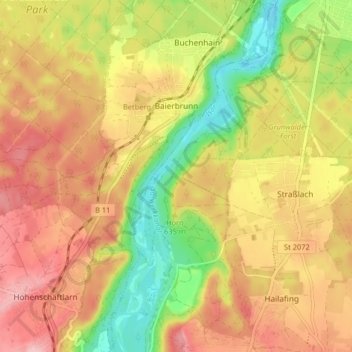
Name: Baierbrunn topographic map, elevation, terrain.
Location: Baierbrunn, Landkreis München, Bayern, 82065, Deutschland (47.98243 11.45980 48.03675 11.50954)
Average elevation: 623 m
Minimum elevation: 537 m
Maximum elevation: 692 m
Make a donation
Gear up for your next adventure:
As an Amazon Associate, this site earns from qualifying purchases at no extra cost to you.
Other topographic maps
Click on a map to view its topography, its elevation and its terrain.
Beigarten
Deutschland > Bayern > Landkreis München > Straßlach-Dingharting > Beigarten
Average elevation: 625 m
Make a donation
Gear up for your next adventure:
As an Amazon Associate, this site earns from qualifying purchases at no extra cost to you.
Make a donation
Gear up for your next adventure:
As an Amazon Associate, this site earns from qualifying purchases at no extra cost to you.
Deisenhofen
Deutschland > Bayern > Landkreis München > Oberhaching
Das Pfarrdorf liegt direkt südlich des Ortsteils Oberhaching am Nordende des Gleißentals auf einer Höhe von 595 m. In dem Ort tritt das durch das Gleißental fließende Grundwasser zutage und bildet den Hachinger Bach.
Average elevation: 592 m
Make a donation
Gear up for your next adventure:
As an Amazon Associate, this site earns from qualifying purchases at no extra cost to you.
Make a donation
Gear up for your next adventure:
As an Amazon Associate, this site earns from qualifying purchases at no extra cost to you.
Make a donation
Gear up for your next adventure:
As an Amazon Associate, this site earns from qualifying purchases at no extra cost to you.
Make a donation
Gear up for your next adventure:
As an Amazon Associate, this site earns from qualifying purchases at no extra cost to you.
Hailafing
Deutschland > Bayern > Landkreis München
Beigarten | Deigstetten | Ebertshausen | Epolding | Frundsbergerhöhe | Gleißentalweiher | Großdingharting | Hailafing | Holzhausen | Kirchlberg | Kleindingharting | Mühlthal | Straßlach
Average elevation: 637 m
Make a donation
Gear up for your next adventure:
As an Amazon Associate, this site earns from qualifying purchases at no extra cost to you.
Make a donation
Gear up for your next adventure:
As an Amazon Associate, this site earns from qualifying purchases at no extra cost to you.
Haar
Deutschland > Bayern > Landkreis München > Haar > Haar
Das Haarer Trinkwasser wurde zunächst in Brunnen am Rande des Gemeindegebietes gefördert. Um die Versorgung des wachsenden Ortes auch für die Zukunft langfristig zu sichern, wurden neue Quellen erschlossen. So stammt seit 2011 das geförderte Wasser aus einem Gebiet im Höhenkirchener Forst, in dem das…
Average elevation: 543 m
Make a donation
Gear up for your next adventure:
As an Amazon Associate, this site earns from qualifying purchases at no extra cost to you.
Make a donation
Gear up for your next adventure:
As an Amazon Associate, this site earns from qualifying purchases at no extra cost to you.