
Ben Lomond topographic map
Interactive map
Click on the map to display elevation.
About this map
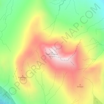
Name: Ben Lomond topographic map, elevation, terrain.
Location: Ben Lomond, Stirling, Scotland, G63 0AR, United Kingdom (56.19031 -4.63334 56.19041 -4.63324)
Average elevation: 575 m
Minimum elevation: 217 m
Maximum elevation: 950 m
Other topographic maps
Click on a map to view its topography, its elevation and its terrain.
Loch Katrine
United Kingdom > Scotland > Stirling
Loch Katrine, Stirling, Scotland, United Kingdom
Average elevation: 349 m
Drymen
United Kingdom > Scotland > Stirling
Drymen, Stirling, Scotland, G63 0BJ, United Kingdom
Average elevation: 59 m