
Devil Canyon topographic map
Click on the map to display elevation.
About this map
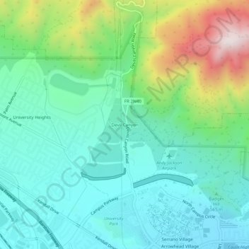
Name: Devil Canyon topographic map, elevation, terrain.
Average elevation: 628 m
Minimum elevation: 432 m
Maximum elevation: 1,165 m
Other topographic maps
Click on a map to view its topography, its elevation and its terrain.
Devils Canyon Dike Number 1 17-002 Dam
United States > California > San Bernardino County > San Bernardino
Average elevation: 519 m
City Creek
United States > California > San Bernardino County > San Bernardino
Average elevation: 363 m