
Thank you for supporting this site ❤️
Make a donation
Make a donation
Gear up for your next adventure:
As an Amazon Associate, this site earns from qualifying purchases at no extra cost to you.
Paynesville topographic map
Click on the map to display elevation.
Thank you for supporting this site ❤️
Make a donation
Make a donation
Gear up for your next adventure:
As an Amazon Associate, this site earns from qualifying purchases at no extra cost to you.
About this map
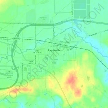
Name: Paynesville topographic map, elevation, terrain.
Location: Paynesville, Stearns County, Minnesota, United States (45.36624 -94.75870 45.39168 -94.69897)
Average elevation: 361 m
Minimum elevation: 344 m
Maximum elevation: 389 m
Thank you for supporting this site ❤️
Make a donation
Make a donation
Gear up for your next adventure:
As an Amazon Associate, this site earns from qualifying purchases at no extra cost to you.
Other topographic maps
Click on a map to view its topography, its elevation and its terrain.
Pearl Lake
United States > Minnesota > Stearns County > Maine Prairie Township
Average elevation: 343 m