
Kreuzberg topographic map
Interactive map
Click on the map to display elevation.
About this map
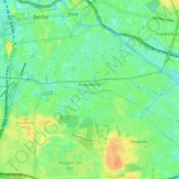
Name: Kreuzberg topographic map, elevation, terrain.
Location: Kreuzberg, Friedrichshain-Kreuzberg, Berlin, Deutschland (52.48279 13.36823 52.50938 13.45293)
Average elevation: 43 m
Minimum elevation: 29 m
Maximum elevation: 67 m
Other topographic maps
Click on a map to view its topography, its elevation and its terrain.
Dahlem
Deutschland > Berlin > Berlin
Dahlem, Steglitz-Zehlendorf, Berlin, 14195, Deutschland
Average elevation: 50 m