
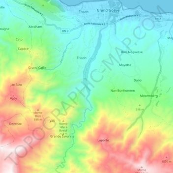
Rivière de Grand Goâve topographic map
Interactive map
Click on the map to display elevation.
About this map
Name: Rivière de Grand Goâve topographic map, elevation, terrain.
Average elevation: 463 m
Minimum elevation: 0 m
Maximum elevation: 1,366 m
Other topographic maps
Click on a map to view its topography, its elevation and its terrain.
La Veine
Haïti > Département de l'Ouest > Commune Grand-Goâve
La Veine, Commune Grand-Goâve, CMRP, Arrondissement de Léogâne, Département de l'Ouest, CHARLEMAGNE, Haïti
Average elevation: 102 m