
Noswendel topographic map
Interactive map
Click on the map to display elevation.
About this map
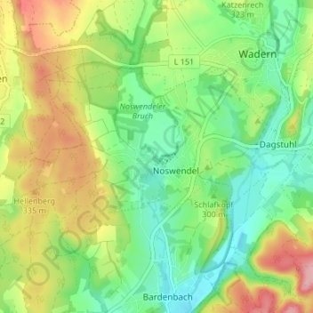
Name: Noswendel topographic map, elevation, terrain.
Average elevation: 305 m
Minimum elevation: 250 m
Maximum elevation: 390 m
Other topographic maps
Click on a map to view its topography, its elevation and its terrain.
Lockweiler
Deutschland > Saarland > Wadern > Lockweiler
Lockweiler, Wadern, Landkreis Merzig-Wadern, Saarland, 66687, Deutschland
Average elevation: 342 m