
Make a donation
Gear up for your next adventure:
As an Amazon Associate, this site earns from qualifying purchases at no extra cost to you.
Riyadh topographic map
Click on the map to display elevation.
Make a donation
Gear up for your next adventure:
As an Amazon Associate, this site earns from qualifying purchases at no extra cost to you.
Riyadh
Riyadh has a hot desert climate (Köppen Climate Classification BWh), with long, extremely hot summers and short, very mild winters. The average high temperature in August is 43.6 °C (110.5 °F). If not for the elevation the city was on, Riyadh would experience an even hotter climate. The city experiences very little precipitation, especially during the summer, but receives a fair amount of rain in March and April. It is also known to have dust storms during which the dust can be so thick that visibility is under 10 m (33 ft). On 1 and 2 April 2015, a massive dust storm hit Riyadh, causing the suspension of classes in many schools in the area and the cancellation of hundreds of flights, both domestic and international.
Make a donation
Gear up for your next adventure:
As an Amazon Associate, this site earns from qualifying purchases at no extra cost to you.
About this map
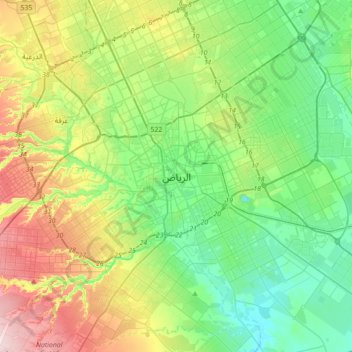
Name: Riyadh topographic map, elevation, terrain.
Average elevation: 630 m
Minimum elevation: 535 m
Maximum elevation: 835 m
Make a donation
Gear up for your next adventure:
As an Amazon Associate, this site earns from qualifying purchases at no extra cost to you.
Other topographic maps
Click on a map to view its topography, its elevation and its terrain.