
Make a donation
Gear up for your next adventure:
As an Amazon Associate, this site earns from qualifying purchases at no extra cost to you.
Riyadh governorate topographic map
Click on the map to display elevation.
Make a donation
Gear up for your next adventure:
As an Amazon Associate, this site earns from qualifying purchases at no extra cost to you.
About this map
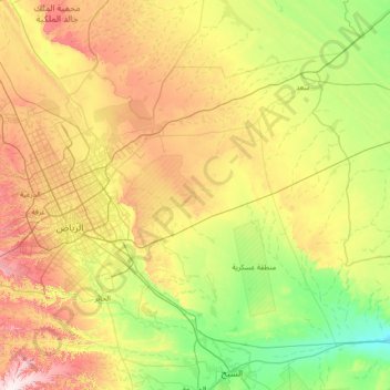
Name: Riyadh governorate topographic map, elevation, terrain.
Location: Riyadh governorate, Riyadh Region, Saudi Arabia (24.22004 46.31679 25.26728 47.74305)
Average elevation: 658 m
Minimum elevation: 414 m
Maximum elevation: 1,079 m
Make a donation
Gear up for your next adventure:
As an Amazon Associate, this site earns from qualifying purchases at no extra cost to you.
Other topographic maps
Click on a map to view its topography, its elevation and its terrain.
Riyadh
Riyadh has a hot desert climate (Köppen Climate Classification BWh), with long, extremely hot summers and short, very mild winters. The average high temperature in August is 43.6 °C (110.5 °F). If not for the elevation the city was on, Riyadh would experience an even hotter climate. The city experiences…
Average elevation: 630 m