
سدير topographic map
Interactive map
Click on the map to display elevation.
About this map
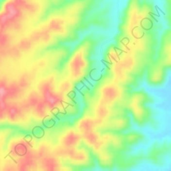
Name: سدير topographic map, elevation, terrain.
Location: سدير, As Sulayyil, Riyadh Region, Saudi Arabia (20.36748 45.36637 20.36758 45.36647)
Average elevation: 689 m
Minimum elevation: 633 m
Maximum elevation: 738 m
Other topographic maps
Click on a map to view its topography, its elevation and its terrain.
As Sulayyil
As Sulayyil, Riyadh Region, Saudi Arabia
Average elevation: 741 m
Riyadh
Riyadh, Al Malaz, Riyadh governorate, Riyadh Region, 11131, Saudi Arabia
Average elevation: 630 m
Riyadh governorate
Riyadh governorate, Riyadh Region, Saudi Arabia
Average elevation: 658 m
Al Malaz Municipality
Al Malaz Municipality, Riyadh, Riyadh Region, Saudi Arabia
Average elevation: 612 m