
Upper Southampton Township topographic map
Interactive map
Click on the map to display elevation.
About this map
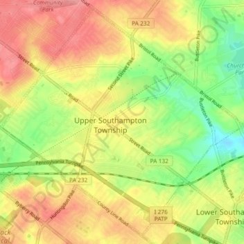
Name: Upper Southampton Township topographic map, elevation, terrain.
Average elevation: 74 m
Minimum elevation: 27 m
Maximum elevation: 115 m
Other topographic maps
Click on a map to view its topography, its elevation and its terrain.
Southampton
United States of America > Pennsylvania > Upper Southampton Township > Southampton
Southampton, Upper Southampton Township, Bucks County, Pennsylvania, 19407, United States of America
Average elevation: 75 m