
Make a donation
Gear up for your next adventure:
As an Amazon Associate, this site earns from qualifying purchases at no extra cost to you.
Reuth topographic map
Click on the map to display elevation.
Make a donation
Gear up for your next adventure:
As an Amazon Associate, this site earns from qualifying purchases at no extra cost to you.
Reuth
Das Pfarrdorf in der naturräumlichen Landschaftseinheit des Regnitztals liegt etwa vier Kilometer östlich des Ortszentrums von Forchheim auf einer Höhe von 332 m ü. NHN und ist mit dem Siedlungsgebiet von Forchheim zusammengewachsen.
Make a donation
Gear up for your next adventure:
As an Amazon Associate, this site earns from qualifying purchases at no extra cost to you.
About this map
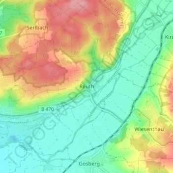
Name: Reuth topographic map, elevation, terrain.
Average elevation: 304 m
Minimum elevation: 260 m
Maximum elevation: 370 m
Make a donation
Gear up for your next adventure:
As an Amazon Associate, this site earns from qualifying purchases at no extra cost to you.