
Make a donation
Gear up for your next adventure:
As an Amazon Associate, this site earns from qualifying purchases at no extra cost to you.
Ramah topographic map
Click on the map to display elevation.
Make a donation
Gear up for your next adventure:
As an Amazon Associate, this site earns from qualifying purchases at no extra cost to you.
Ramah
Lying at 6,926 feet (2,111 m) above sea level, Ramah is considered by some as a high desert, but at higher elevations it includes tall pines, sandstone cliffs, and timber-covered mountains. Much of the lower landscape in the surrounding area is covered with lava flows from the chain of volcanos to the south.
Make a donation
Gear up for your next adventure:
As an Amazon Associate, this site earns from qualifying purchases at no extra cost to you.
About this map
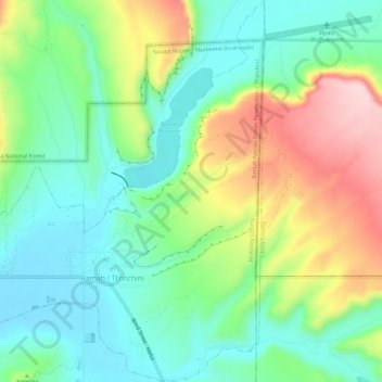
Name: Ramah topographic map, elevation, terrain.
Location: Ramah, McKinley County, New Mexico, United States (35.12004 -108.51534 35.16785 -108.46848)
Average elevation: 2,184 m
Minimum elevation: 2,095 m
Maximum elevation: 2,354 m
Make a donation
Gear up for your next adventure:
As an Amazon Associate, this site earns from qualifying purchases at no extra cost to you.