
Make a donation
Gear up for your next adventure:
As an Amazon Associate, this site earns from qualifying purchases at no extra cost to you.
Fianarantsoa topographic map
Click on the map to display elevation.
Make a donation
Gear up for your next adventure:
As an Amazon Associate, this site earns from qualifying purchases at no extra cost to you.
Fianarantsoa
It is at an average altitude of 1,200 metres (3,900 ft), and has a population of 191,766.
Make a donation
Gear up for your next adventure:
As an Amazon Associate, this site earns from qualifying purchases at no extra cost to you.
About this map
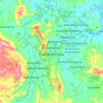
Name: Fianarantsoa topographic map, elevation, terrain.
Average elevation: 1,172 m
Minimum elevation: 1,064 m
Maximum elevation: 1,514 m
Make a donation
Gear up for your next adventure:
As an Amazon Associate, this site earns from qualifying purchases at no extra cost to you.
Other topographic maps
Click on a map to view its topography, its elevation and its terrain.
Fianarantsoa
Madagascar > Haute Matsiatra > District de Fianarantsoa > Fianarantsoa
Average elevation: 1,201 m