
Encinitas topographic map
Click on the map to display elevation.
Encinitas
Encinitas lies on rugged coastal terrace. The city is bisected by a low-lying coastal ridge that separates New and Old Encinitas. In the north of the city, the coast rises in elevation and the land is raised up in the form of many coastal bluffs. These cliffs are subject to collapsing on the narrow beach. The city is bounded by Batiquitos Lagoon to the north and San Elijo Lagoon to the south.
About this map
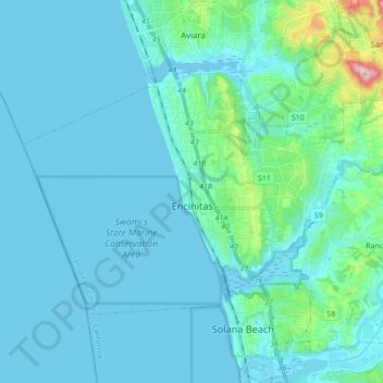
Name: Encinitas topographic map, elevation, terrain.
Location: Encinitas, San Diego County, California, United States (32.99599 -117.36829 33.08872 -117.19557)
Average elevation: 32 m
Minimum elevation: -1 m
Maximum elevation: 317 m
Other topographic maps
Click on a map to view its topography, its elevation and its terrain.