
Make a donation
Gear up for your next adventure:
As an Amazon Associate, this site earns from qualifying purchases at no extra cost to you.
Goldap topographic map
Click on the map to display elevation.
Make a donation
Gear up for your next adventure:
As an Amazon Associate, this site earns from qualifying purchases at no extra cost to you.
Goldap
Die Stadt liegt rund 130 Kilometer südöstlich von Kaliningrad (Königsberg, Russland) und etwa 200 km südwestlich von Vilnius (Wilna, Litauen) an der Grenze zur Oblast Kaliningrad (Königsberger Gebiet) im historischen Ostpreußen. Dort befindet sie sich an den Nordausläufern der Seesker Höhen am Flüsschen Goldap (Gołdapa), nahe dem Wald-, Mittelgebirgs- und Heidegebiet Rominter Heide (prußisch ram, rom: still, heilig).
Make a donation
Gear up for your next adventure:
As an Amazon Associate, this site earns from qualifying purchases at no extra cost to you.
About this map
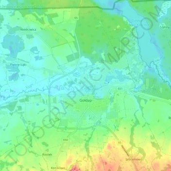
Name: Goldap topographic map, elevation, terrain.
Average elevation: 167 m
Minimum elevation: 141 m
Maximum elevation: 241 m
Make a donation
Gear up for your next adventure:
As an Amazon Associate, this site earns from qualifying purchases at no extra cost to you.
Other topographic maps
Click on a map to view its topography, its elevation and its terrain.
Zameczna Góra
Polen > Woiwodschaft Ermland-Masuren > powiat gołdapski > Collnischken
Average elevation: 229 m