Geolocate

Canegreca topographic map

Click on the map to display elevation.

About this map

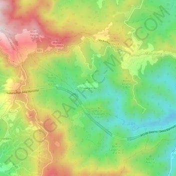
Name: Canegreca topographic map, elevation, terrain.

Location: Canegreca, Carrodano, La Spezia, Liguria, 19012, Italy (44.21926 9.58275 44.25926 9.62275)

Average elevation: 460 m

Minimum elevation: 201 m

Maximum elevation: 788 m

Gear up for your next adventure:

🦯Adjustable Trekking Poles - Reduce impact on knees when descending steep topographic ridges
☀️Portable Solar Chargers - High-efficiency panels to hang on your backpack while walking
🥤Hydration Packs - Hydration systems for hiking
🕶️Polarized Sunglasses - UV protection sunglasses for outdoors
🧼Biodegradable Soap - Eco-friendly outdoor soap

As an Amazon Associate, this site earns from qualifying purchases at no extra cost to you.